Comprehensive transboundary bibliography review

The Milk River Transboundary Aquifer Project includes a comprehensive review of the previous studies on both sides of the USA-Canada border.
The previous geological,hydrogeological and geochemical studies of the Milk River Aquifer have been gathered and compiled. This review allowed to identify the less-documented areas which have been therefore visited during the field work.
Unified database of the Milk River Aquifer
Since most of the previous studies were limited by the USA-Canada border, we aim to overcome transboundary limitations by providing a unified database of the Milk River Aquifer.
Geological data, geochemical results, water levels measurements, observation wells data and hydrogeological properties of the aquifer are gathered in order to propose a unique database of the Milk River Aquifer.
Geological data, geochemical results, water levels measurements, observation wells data and hydrogeological properties of the aquifer are gathered in order to propose a unique database of the Milk River Aquifer.
Field work
The objective of the field work was to:
1) Measure water levels in wells drilled in the Milk River Aquifer
2) Collect groundwater samples from the Milk River Aquifer for isotopic analysis (Tritium, Carbon 14 and Chlorine 36)
3) Measure the pressure of flowing artesian wells.
4) Conduct a survey with landowners (status of the well, depth, estimated use, water quality...)
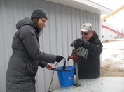
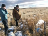
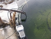
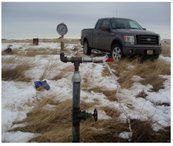
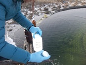
3 field works have been carried out since 2012 within the study area:
- December 2012 in southern Alberta (Marie-Amélie Pétré and Clarisse Deschêne-Rancourt, INRS-ETE; Daryl Jaques, Agriculture and Agri-Food Canada).
A flyer (available here) explaining the purpose of the study has been sent to the well owners of the study area prior to the field work
13 static water levels measurements and 17 groundwater samples (17 for Carbon 14, 16 for tritium and 10 for Chlorine 36 analysis), survey conducted with 13 owners.
- Summer 2013 in northern Montana (USGS- Helena Office) 11 groundwater samples and water levels measurements, survey conducted with 10 owners.
- December 2013 in southern Alberta (Davison Environmental Consulting): 8 static water level measurements, 4 pressure measurements from flowing wells, survey in southern Alberta and northern Montana
We thank all the landowners who gave us access to their well during the field work, your support was greatly appreciated!
1) Measure water levels in wells drilled in the Milk River Aquifer
2) Collect groundwater samples from the Milk River Aquifer for isotopic analysis (Tritium, Carbon 14 and Chlorine 36)
3) Measure the pressure of flowing artesian wells.
4) Conduct a survey with landowners (status of the well, depth, estimated use, water quality...)
3 field works have been carried out since 2012 within the study area:
- December 2012 in southern Alberta (Marie-Amélie Pétré and Clarisse Deschêne-Rancourt, INRS-ETE; Daryl Jaques, Agriculture and Agri-Food Canada).
A flyer (available here) explaining the purpose of the study has been sent to the well owners of the study area prior to the field work
13 static water levels measurements and 17 groundwater samples (17 for Carbon 14, 16 for tritium and 10 for Chlorine 36 analysis), survey conducted with 13 owners.
- Summer 2013 in northern Montana (USGS- Helena Office) 11 groundwater samples and water levels measurements, survey conducted with 10 owners.
- December 2013 in southern Alberta (Davison Environmental Consulting): 8 static water level measurements, 4 pressure measurements from flowing wells, survey in southern Alberta and northern Montana
We thank all the landowners who gave us access to their well during the field work, your support was greatly appreciated!
|
|
Credit: Davison Environmental Consulting
|
|
Building of a 3D unified geological model of the Milk River Transboundary Aquifer
Before moving to the hydrogeological part of the study, it is crucial to have a sound understanding of the stratigraphy and the geometry of the geological units in the study area.
Therefore, a 3D unified geological model of the Milk River Transboundary Aquifer has been built. The available geological data in northern Montana and southern Alberta have been gathered and processed in order to have a homogeneous and unified database.
This model covers circa 50,000 km2 in southern Alberta and northern Montana. The 3 members of the Milk River Formation (and especially the middle Virgelle Member/Milk River Aquifer) have been represented continuously through the international border.
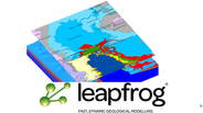
Leapfrog Hydro has been used, it is a recent software for geological modeling. It has been chosen mostly for its interoperability with FEFLOW.
The methodology and results of the unified geological model are presented in a scientific paper (Pétré et al. 2015).
This unified geological model will form the basis for a future three-dimensional numerical hydrogeological model of groundwater flow in the Milk River Aquifer across the Canada-US border.
Therefore, a 3D unified geological model of the Milk River Transboundary Aquifer has been built. The available geological data in northern Montana and southern Alberta have been gathered and processed in order to have a homogeneous and unified database.
This model covers circa 50,000 km2 in southern Alberta and northern Montana. The 3 members of the Milk River Formation (and especially the middle Virgelle Member/Milk River Aquifer) have been represented continuously through the international border.
Leapfrog Hydro has been used, it is a recent software for geological modeling. It has been chosen mostly for its interoperability with FEFLOW.
The methodology and results of the unified geological model are presented in a scientific paper (Pétré et al. 2015).
This unified geological model will form the basis for a future three-dimensional numerical hydrogeological model of groundwater flow in the Milk River Aquifer across the Canada-US border.
Work completed by Dec. 2016
- Complete the Conceptual Unified Model of the Milk River Aquifer (including groundwater flow, geochemistry and groundwater dating...)
- Obtain missing data on surface water and groundwater use in the study area
- Build a 3D numerical hydrogeological model of groundwater flow in the Milk River Aquifer across the USA-Canada border (using FEFLOW)
- Quantify groundwater availability and sustainability with the calibrated numerical model
- Propose recommandations for the sustainable use of the Milk River Transboundary Aquifer, following the UNGA resolution 63/124 on the Law of
Transboundary Aquifers
